MURTON PARISH
Where is Murton?
Murton Parish lies on the eastern edge of the city, between two main roads radiating out from York, one to Hull and the other to Scarborough. The Parish’s western boundary is about 3 km from the centre of York and the Minster can be seen clearly from many parts of the Parish including the village.
FIGURE 1 MAP SHOWING YORK
The Parish enjoys the close proximity to a major trunk road, A64, leading from Leeds to Scarborough which links to the main north-south roads, M1 and A1 and thence to the east-west M62. Thus within a very short time, the Parish is connected to major roads to London, Newcastle, Leeds, Manchester and Liverpool. Moreover, we are within 6 km of York railway station which provides fast trains to London, Newcastle and Edinburgh and the east-west system to Leeds, Manchester and Liverpool, scheduled to be upgraded.
What is the total population of Murton Parish?
The 2011 census gives a total of 668 inhabitants and there are 480 on the Parish electoral roll.
How large is the Parish?
The Parish occupies an area of ca 340 hectares.
Is Murton in the Green Belt?
The Parish is given strategic importance in the emerging City of York Local Plan, being in the Green Belt. Murton is identified as one of the 12 ‘washed-over’ parishes circling York which defines this inner boundary of the Green Belt in the emerging Local Plan. These villages are included, as their ‘open character’ contributes ‘to the openness of the Green Belt’.
Where are the main areas of housing in the Parish?
Most of the houses in the Parish are in two distinct areas. One is the village at the heart of the Parish, with ca 140 dwellings.
The village has a core designated as a Conservation area (Figure 3), in which there are some interesting 18th and early 19th century houses, and a small church thought to date back to the early 13th century. Contiguous with the conservation area are houses, mainly built in the 1960s up to early 2000s. Half the houses in the village are detached and almost all of the rest are semi-detached.
The other main residential area is on the southern boundary of the Parish and the majority of the 127 dwellings were constructed as a single development in the mid-1990s in a uniform way and with a mix of semi-detached, terraced houses and flats and only a small proportion (7%) of detached houses.
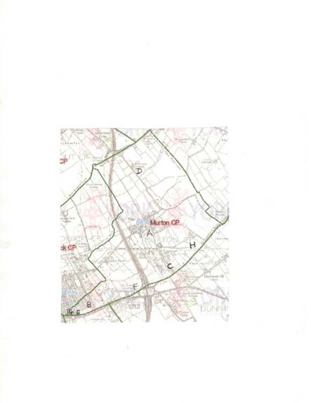
The other houses on the southern fringe are along the Hull Road and down Tranby Avenue which is at right angles to it and, adjoining Tranby Avenue, there is Cavendish Grove (Figure 2, G). There are a few houses along the Hull Road at Grimston and the Stamford Bridge Road which are at the outermost south-eastern edge of the Parish (Figure 2, H).
Below are two possible Figure 2s). We would have to get permission to use either for our website.
The original has a clear red line showing the boundary
 This is Figure 3
Where are the employment sites in the Parish?
There are many regional and local companies within the Parish boundary which paly an important role in he economy.
There are three specific areas devoted to businesses and industry:
- an area adjacent to the A166, the York-Stamford Bridge Road (Appendix I, Figure 1, C), the Murton Business Park
- an area along Moor Lane (Appendix I, Figure 1, D).
- an area occupied by two businesses along the Hull Road, adjacent to one other (Appendix I, Figure 1, E).
Among the larger companies in the Murton Business Park is ABP Food Group, a major international meat processing company and William Thompson (York) Ltd, part of the BATA Group, one of the largest animal feed companies in the North-East at which there is a Country Store. There are also several other significant businesses in this area which have a strong agricultural bias. They include Holmfield Agricultural Services which is a veterinary service and animal food supplier, the York Auction (Livestock) Centre which serves farmers over a wide area of Yorkshire and further afield and has the offices of Stephenson and Sons, the leading independent auctioneers in Yorkshire, a company that is over 140 years old. Another family company with an even longer history, over150 years, is a leading regional recycling centre, L Clancey and Sons.
Nearby in this area, Yorkshire Handlers deal with agricultural machinery and Trustspan is a national timber engineering company and a host of small companies, several of which are specialist car maintenance companies with high expertise.
The Yorkshire Museum of Farming is also in this area and it plays an important educational role for schools across Yorkshire and the Derwent Light Railway at Murton Station provides a wonderful evocation of steam trains that used to pass through Murton on their way from York into the old East Riding of Yorkshire. Both the Museum and the railway are a great heritage for Murton to have.
The second area contains a smaller group of local businesses grouped together in an area along Moor Lane (Appendix A, Figure 2, D) known as Moor Lane Farm. Nearby is Beetle Bank Farm, an Open Farm and Education Centre.
The third area contains a B and Q store and a much frequented petrol station with a convenience store.
The businesses in the first two areas are clearly separate from the two settlements but the third (Hull Road) is close to the development adjacent to the Hull Road.
Much the largest area which has profound environmental consequences for the Parish is occupied by farmland. The farmers additionally provide us with our environment, crucial for our overall pleasure and well-being which is recognized in the Neighbourhood Plan.
Another and increasingly important sector in Murton, which reflects the general changes of employment in the UK, are those engaged in work from their own homes and are self-employed. These include a business devoted to horse breeding with livery stables and a cattery. There are other businesses which depend crucially on fast communications (e.g. journalism).